From the North: Take Highway 101 to Oxnard. Take Rice Ave exit and turn towards the ocean. Rice Ave becomes Highway 1 South, the Pacific Coast Highway. Continue on PCH until you come to the Neptune’s Net Seafood Restaurant (42505 PCH), 3 miles past the Sycamore Canyon State Park. Neptune’s Net will be on your left, park in the dirt lot on your right.
From the South: Take Highway 1/PCH Northbound. Continue along PCH past Pepperdine and Leo Carrillo State Park until you come to the Neptune’s Net Seafood Restaurant.
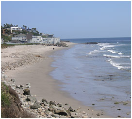
The monitoring site is located to the east of the parking lot, along a broad sandy beach.
Parking:
Park in the dirt lot across from Neptune’s Net on the Pacific Coast Highway.
Restrooms:
Portable bathrooms are located at the west end of the dirt parking lot and across the street at the restaurant.